How to reach the Lawlogg clubroom
There is a LOT of detail below. It would probably be sensible to view this page on a decent-sized PC screen rather than a small phone or tablet!
Anyone intending to visit independently on a Wednesday or Friday evening is requested to let us know, in advance of their proposed visit, using the contact form on this page if they have not already done so. However, those coming to one of our general Open Days, or as part of a pre-arranged meeting into which they have already booked (e.g. with MERG etc.), can ignore this request.
Driving information and maps are provided for two main directions, from the North on Map 1 and from the West (Wirral peninsula tunnels and Liverpool city centre) and South/East, (via the motorways etc.) on Map 2.
(Public transport & walking information, plus car parking details etc. are below the driving maps.)
The postcode for your satnav is L20 9JD but please read the detailed descriptions below.
For users of “What Three Words”, you can use “caged.flute.jets“.
Address: 1st floor, St Monica’s Parish Centre, Stewart Avenue, BOOTLE, L20 9JD
(A printable A4 summary pdf is downloadable at the bottom of the page.)
Drivers might also want to click to this map on the morning of the intended visit and zoom in to see the detail of any ‘live’ roadworks and planned road closures. (You’ll need to click on any roadworks symbols to see whether the date/time of the roadworks will affect your journey.)
From the North
[MAIN MAP 1]
(M6>M58 / A59 / A565>A5758)
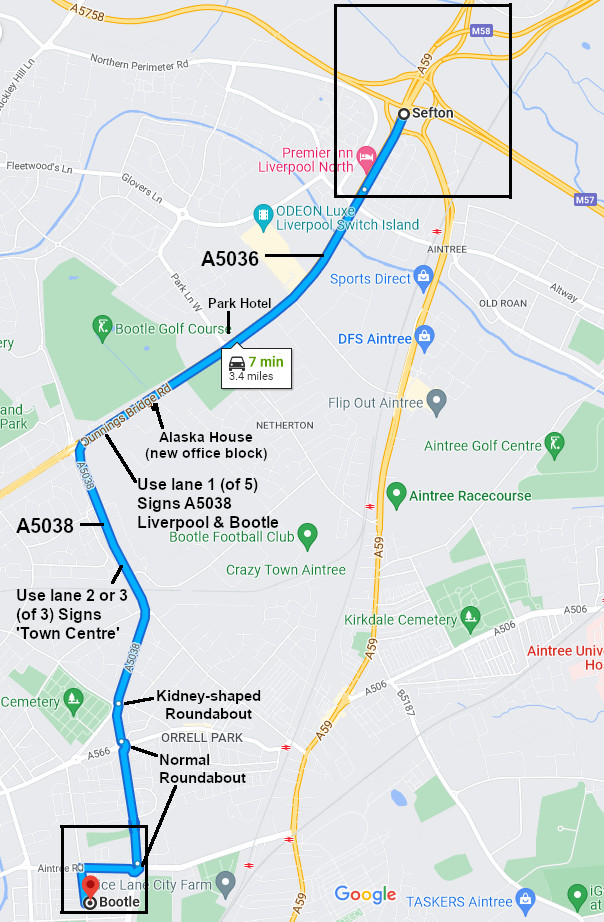
BEWARE! There are now average speed cameras installed for the last mile of the M57, where the speed limit drops to 50, then 40.
Your SatNav might direct you along the A59 south from the above junction but, depending on the day and time, the A59 can be a horrendously congested and densely populated route through ‘Walton Vale’. The A5036 is recommended as an alternative.
Detail of the upper black box from main map 1, above, is shown below.

The junction shown above (known locally as ‘switch island’) is notoriously complex and confusing. Visitors are strongly advised to use ‘Streetview’ in Google Maps to rehearse their path through this junction, prior to travelling! (Click here to open the relevant google map in a new tab, then (on a PC) drag the little yellow human symbol from the corner and drop it on to the road you will be using to approach the junction, or (on a mobile) click and hold the road location then select streetview window. Click the arrows on screen to navigate through the junction to the A5036 (signed Bootle & Docks).)
After 1½ miles, turn left (lane 1) on to A5038 (signed Liverpool & Bootle).
Beware that there are many speed cameras (and, sometimes, mobile speed camera vans) along the suggested route. Speed limit(*) along the A5036 is 40mph BUT along the A5038 is 30mph (despite being a dual carriageway). (*) as at March 2024
Detail of the lower black box from main map 1, above, is shown below.
(See below for car park details & entrance door to use etc.)
From the East, the South and Wirral Peninsula
[MAIN MAP 2]
From the East Lancs. Road (A580) or from the south & east (M6>M62>M57 j4>A580) or from Liverpool city centre and Wirral peninsula (M53/A41>A59)

From south & east via motorways:
From the M6 > M62 > M57, take M57 j4 for the A580 (East Lancs. Road) signed for ‘Knowsley & Industrial Park / Bootle‘, taking the first exit off junction 4 roundabout, signed ‘Liverpool / Bootle‘ then follow signs for ‘City Centre‘ (for approx 3 miles) until the junction with the A5058, turning right just after Walton Hall Park (on your right hand side), on to Queen’s Drive ring road (signed Southport / Bootle / Docks, A5058), as shown above on map 2 (near the top RHS). Continue over Queen’s Drive flyover on to Breeze Hill then take lane 3 and turn right at the lights shortly after the flyover (~500 yds). (Hillside High School is on the RHS.) Signed for ‘Southport / Hawthorne Road Industrial Area, A5038’. Then as per bottom map (‘final section’), below.
Depending on traffic, it is sometimes quicker (despite being slightly further) just to stay on the M57 to its end and go via ‘switch island’ then A5036/8 (as per Map 1) but it is somewhat ‘pot luck’ with traffic, whichever way you go, depending on day and time etc. The presence of local football matches can also skew results! If you have live updates to your SatNav (e.g. Android (Google) Maps with data switched on), it will probably give you the fastest route at the time.
From the Wirral peninsula and Liverpool city centre:
Detail of the lower black box from main map 2, above, is shown below:
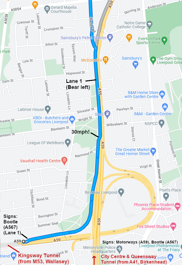
The blue route is shown from the Wallasey Tunnel and is the most likely (with the Birkenhead Tunnel & city centre routes indicated in red letters at the bottom) – head initially for the A59. Beware that the speed limit on leaving both tunnels is 30mph, with multiple traffic-light-jumping and speed cameras immediately encountered along that route.
Your SatNav might continue to direct you along the A59 but this can be a horrendously congested and densely populated route. Our recommendation is to leave the A59 about 400 yards after the Wallasey Tunnel slip road and bear left to use the A567 (signed, ‘Bootle, Docks‘) as you pass McDonalds/KFC (on your right).
Proceed north along Stanley Road (A567) for about ¾ mile then turn right on to Melrose Road (A5038 (unsigned!)) at the traffic lights by large ‘Kiddieland’ pram shop on your left. (Marked on main map 2.) Be aware that the single carriageway becomes dual carriageway at the next traffic lights (Melrose Abbey pub on the right) but note that you are then facing the oncoming traffic. (Bear slightly left to proceed (signed ‘Walton‘).
Final section: From both Main Map 2 (above) and Wirral Map (above) –
Detail of the upper black box from main map 2, is shown below:

If following blue route from M57 j4 > A580 > A5058 at the bottom right of the map, turn right at lights on to A5038 (Southport Road) and after about 150 yards, turn left on to Oxford Road then first right into Fernhill Road. Stewart Avenue is the 3rd right just beyond the big 1920s brick church past Derby Park.
If following the blue route from the Wirral/city centre at the bottom of this map, proceed over the major junction at the former pub (to be McDonalds site?) ‘The Mons’ (large 1960s concrete pub) on your left. (Signs ‘ Southport / Hawthorne Road Industrial Area, A5038‘)
Then after about 150 yards, turn left on to Oxford Road then first right into Fernhill Road. Stewart Avenue is the 3rd right just beyond the big 1920s brick church past Derby Park.
There are multiple possible routes from the city centre northwards. If you find yourself on Vauxhall Road (A5038), keep going. It becomes Commercial Road and swings round to cross Stanley Road, becoming Melrose Road (picking up the blue route).
If you find yourself on Regent Road (passing the docks) or on Gt. Howard St./Derby Road (A565), the easiest option is to turn right on to Sandhills Lane to go under Sandhills Station, then turn left (at the T-junction at the top of the hill) on to Commercial Road (A5038) and pick up the blue route, as listed above.
Once you arrive:

If there is an event in the function room downstairs and the car park is busy, there is additional parking to the right of the building and round the back.
If the car park is full, there is usually plenty of free parking alongside Derby Park just past St Monica’s church, diagonally opposite on Fernhill Road. (Please don’t park on Stewart Avenue causing obstruction for the houses.)
Turn the door knob fully anti–clockwise (until it clicks) before pulling the door, in order to stop the floor latch dragging – it’s a conventional ‘push bar’ fire exit on the inside. Please close the door after you. Go up the stairs and ring the door-bell (left hand side) if the upper right-hand door is not already unlocked.
Public Transport
Put L20 9JD as the destination into this link. It will provide you with various alternative public transport options from your own postcode.
All three of Merseyrail’s “Northern Lines” have stations nearby. Walton (Ormskirk line) is slightly nearer than Bootle New Strand (Southport line) and avoids walking up the hill on Marsh Lane. Depending on walking speed, allow about 15-20mins walk from Walton or 20-25mins from Bootle New Strand or Rice Lane (Kirkby (Headbolt Lane) line) – or take a 3-5min bus ride – though unless you time it right, you may find you could have walked it by the time a bus arrives.
Pdf rail timetables for the Northern lines can be downloaded from this link.
Live train information (showing any current delays etc.) is available from this link.
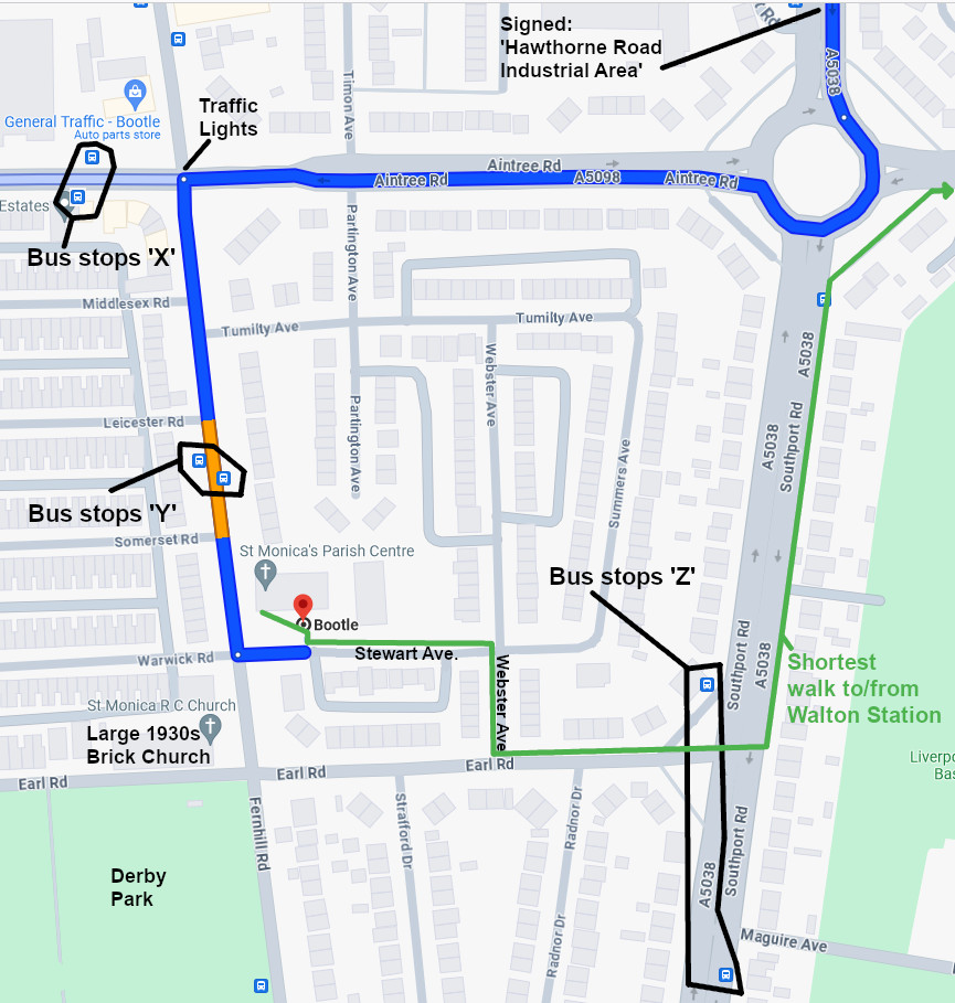
The nearest bus stops are shown above, on the third map down. The shortest walking route to/from Walton railway station is shown on that map in green.
Services 68/68A/68B/68E and 300 run past Walton & Rice Lane stations (on the same side of Hornby Road as the stations) towards Bootle New Strand and call at bus stops shown on the third map down as ‘X’. (Aintree Rd/ adj. Fernhill Rd.)
In the other direction, the various 68s start from Bootle New Strand bus station stand 6 (at the rear of New Strand shopping centre, diagonally opposite the railway station) and call at bus stops shown as ‘X’. (Aintree Rd/ adj. Fernhill Rd.)
Service 300 runs past the front of Bootle New Strand shopping centre on Stanley Road at stop B. (If arriving at Bootle New Strand railway station and intending to catch a 300, it might (depending on timings) be slightly more useful to cross over the road, bear left past the police station and walk along Marsh Lane, crossing the lights by the Lidl, then over the road to the bus stop adjacent to Thornton Road, opposite Lidl’s car park entrance (right in front of the tanning salon) as that’s equidistant to the front of the New Strand shopping centre but it’s the next stop further on, so you’re more likely to catch it there – and all the 68s as well as the 300 stop there.) Alight at bus stops shown as ‘X’ (Aintree Rd/adj. Fernhill Rd.)
Services 135 (stand 5) / 235 (stand 1) start from New Strand bus station (at the rear of New Strand shopping centre, diagonally opposite the railway station) and call at bus stops shown as ‘Y’. (Fernhill Rd/ adj. Leicester Rd).
Service 56 runs from Liverpool (Sir Thomas St) to bus stops shown as ‘Z’, (Southport Rd / adj. Earl Rd)
Pdf bus timetables can be downloaded from this link. (Put the relevant bus service number from the list above into the search box.)
Approximate timings at each bus stop (and live bus tracking maps!) are available from this link. (Click on your relevant departure stop to see a list of services then click the blue link in that pop-up to see a list of approx. timings.)
Downloadable / Printable PDF
Click the download button (below the preview window) to download a printable summary version of these details.

You must be logged in to post a comment.